


SityTrail - RS-Beaucroissant-Les étangs

raymondfn
User
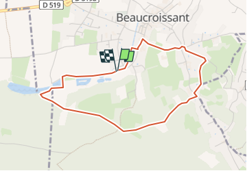

Length
4.2 km

Max alt
477 m

Uphill gradient
69 m
Km-Effort
5.1 km

Min alt
421 m

Downhill gradient
70 m
Boucle
Yes
Creation date :
2024-07-30 12:37:06.801
Updated on :
2024-07-30 13:41:30.224
1h09
Difficulty : Easy

FREE GPS app for hiking
 SityTrail
IGN / Geographical institutes
SityTrail Plus
The world is yours!
About
Trail Walking of 4.2 km to be discovered at Auvergne-Rhône-Alpes, Isère, Beaucroissant. This trail is proposed by raymondfn.
Description
Rando Santé
Positioning
Country:
France
Region :
Auvergne-Rhône-Alpes
Department/Province :
Isère
Municipality :
Beaucroissant
Location:
Unknown
Start:(Dec)
Start:(UTM)
693227 ; 5023246 (31T) N.
Comments