


col de combales

sdroneau
User
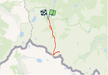

Length
23 km

Max alt
2705 m

Uphill gradient
1290 m
Km-Effort
41 km

Min alt
1477 m

Downhill gradient
1289 m
Boucle
Yes
Creation date :
2024-07-30 05:32:29.098
Updated on :
2024-07-30 15:56:22.414
6h39
Difficulty : Very difficult

FREE GPS app for hiking
 SityTrail
IGN / Geographical institutes
SityTrail Plus
The world is yours!
About
Trail Walking of 23 km to be discovered at Occitania, Hautespyrenees, Arrens-Marsous. This trail is proposed by sdroneau.
Positioning
Country:
France
Region :
Occitania
Department/Province :
Hautespyrenees
Municipality :
Arrens-Marsous
Location:
Unknown
Start:(Dec)
Start:(UTM)
722901 ; 4751479 (30T) N.
Comments