


depart le bessay

gerardmicheline
User
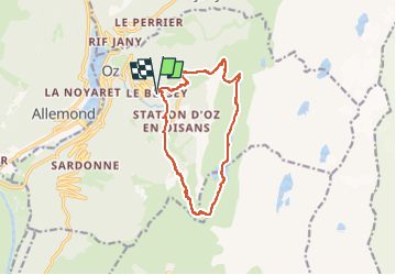

Length
13 km

Max alt
2093 m

Uphill gradient
971 m
Km-Effort
26 km

Min alt
1162 m

Downhill gradient
974 m
Boucle
Yes
Creation date :
2024-07-31 15:35:12.814
Updated on :
2024-07-31 15:35:55.127
5h53
Difficulty : Very difficult

FREE GPS app for hiking
 SityTrail
IGN / Geographical institutes
SityTrail Plus
The world is yours!
About
Trail Walking of 13 km to be discovered at Auvergne-Rhône-Alpes, Isère, Oz. This trail is proposed by gerardmicheline.
Positioning
Country:
France
Region :
Auvergne-Rhône-Alpes
Department/Province :
Isère
Municipality :
Oz
Location:
Unknown
Start:(Dec)
Start:(UTM)
269327 ; 5002177 (32T) N.
Comments