


6847008

topolino
User
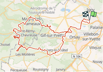

Length
55 km

Max alt
175 m

Uphill gradient
804 m
Km-Effort
66 km

Min alt
58 m

Downhill gradient
805 m
Boucle
Yes
Creation date :
2024-08-01 07:54:18.0
Updated on :
2024-08-01 07:54:20.805

FREE GPS app for hiking
 SityTrail
IGN / Geographical institutes
SityTrail Plus
The world is yours!
About
Trail of 55 km to be discovered at Ile-de-France, Essonne, Igny. This trail is proposed by topolino.
Positioning
Country:
France
Region :
Ile-de-France
Department/Province :
Essonne
Municipality :
Igny
Location:
Unknown
Start:(Dec)
Start:(UTM)
442883 ; 5397181 (31U) N.
Comments