


goupilliere

martinjacque
User
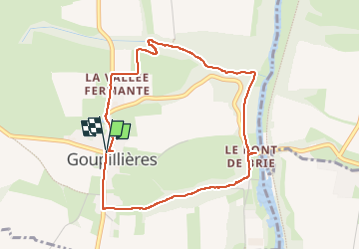

Length
4 km

Max alt
120 m

Uphill gradient
100 m
Km-Effort
5.3 km

Min alt
21 m

Downhill gradient
99 m
Boucle
Yes
Creation date :
2024-08-01 08:17:15.751
Updated on :
2024-08-01 10:12:53.221
1h55
Difficulty : Easy

FREE GPS app for hiking
 SityTrail
IGN / Geographical institutes
SityTrail Plus
The world is yours!
About
Trail Walking of 4 km to be discovered at Normandy, Calvados, Montillières-sur-Orne. This trail is proposed by martinjacque.
Description
Belle balade ombragée. assez pentu.
Positioning
Country:
France
Region :
Normandy
Department/Province :
Calvados
Municipality :
Montillières-sur-Orne
Location:
Unknown
Start:(Dec)
Start:(UTM)
684211 ; 5434197 (30U) N.
Comments