


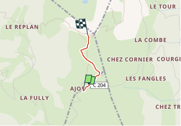
Pointe de Miribel

olivieraron
User

Length
1 km

Max alt
1562 m

Uphill gradient
152 m
Km-Effort
2.5 km

Min alt
1403 m

Downhill gradient
3 m
Boucle
No
Creation date :
2024-08-01 11:07:49.0
Updated on :
2024-08-01 11:07:50.032
34m
Difficulty : Easy

FREE GPS app for hiking
 SityTrail
IGN / Geographical institutes
SityTrail Plus
The world is yours!
About
Trail Walking of 1 km to be discovered at Auvergne-Rhône-Alpes, Upper Savoy, Onnion. This trail is proposed by olivieraron.
Positioning
Country:
France
Region :
Auvergne-Rhône-Alpes
Department/Province :
Upper Savoy
Municipality :
Onnion
Location:
Unknown
Start:(Dec)
Start:(UTM)
305081 ; 5119940 (32T) N.
Comments