


Allemond : Boucle vers gite les Chalanches

manumax
User
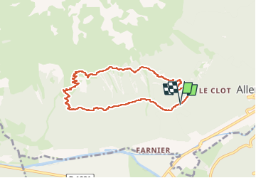

Length
8.4 km

Max alt
1783 m

Uphill gradient
649 m
Km-Effort
17 km

Min alt
1124 m

Downhill gradient
646 m
Boucle
Yes
Creation date :
2024-08-01 07:36:44.269
Updated on :
2024-08-06 12:44:16.72
2h31
Difficulty : Difficult

FREE GPS app for hiking
 SityTrail
IGN / Geographical institutes
SityTrail Plus
The world is yours!
About
Trail Walking of 8.4 km to be discovered at Auvergne-Rhône-Alpes, Isère, Allemond. This trail is proposed by manumax.
Positioning
Country:
France
Region :
Auvergne-Rhône-Alpes
Department/Province :
Isère
Municipality :
Allemond
Location:
Unknown
Start:(Dec)
Start:(UTM)
265488 ; 5001551 (32T) N.
Comments