


Casemate du Donon

LUTZMarc
User
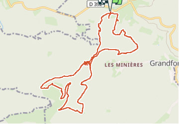

Length
13.7 km

Max alt
892 m

Uphill gradient
356 m
Km-Effort
18.5 km

Min alt
688 m

Downhill gradient
356 m
Boucle
Yes
Creation date :
2024-08-01 07:16:59.986
Updated on :
2024-11-01 07:39:23.837
3h47
Difficulty : Medium

FREE GPS app for hiking
 SityTrail
IGN / Geographical institutes
SityTrail Plus
The world is yours!
About
Trail Walking of 13.7 km to be discovered at Grand Est, Bas-Rhin, Grandfontaine. This trail is proposed by LUTZMarc.
Description
Circuit en forêt le long d’ouvrage militaire de la guerre 14/18.
Passage en tunnel sous terrain , prévoir lampe torche.
Positioning
Country:
France
Region :
Grand Est
Department/Province :
Bas-Rhin
Municipality :
Grandfontaine
Location:
Unknown
Start:(Dec)
Start:(UTM)
362597 ; 5374146 (32U) N.
Comments