


Sentier du pont blanc

caze
User
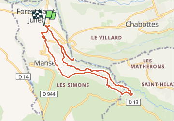

Length
11 km

Max alt
1293 m

Uphill gradient
308 m
Km-Effort
15.1 km

Min alt
1052 m

Downhill gradient
307 m
Boucle
Yes
Creation date :
2024-08-02 09:26:22.0
Updated on :
2024-08-02 13:36:14.596
3h36
Difficulty : Difficult

FREE GPS app for hiking
 SityTrail
IGN / Geographical institutes
SityTrail Plus
The world is yours!
About
Trail Walking of 11 km to be discovered at Provence-Alpes-Côte d'Azur, Hautes-Alpes, Forest-Saint-Julien. This trail is proposed by caze.
Positioning
Country:
France
Region :
Provence-Alpes-Côte d'Azur
Department/Province :
Hautes-Alpes
Municipality :
Forest-Saint-Julien
Location:
Unknown
Start:(Dec)
Start:(UTM)
272792 ; 4947225 (32T) N.
Comments