


GR_34_CH_21_Plouezec_Paimpol_20240802

patrickdanilo
User
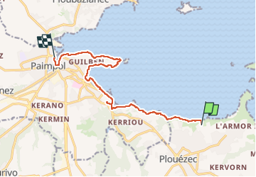

Length
11.5 km

Max alt
61 m

Uphill gradient
167 m
Km-Effort
13.9 km

Min alt
0 m

Downhill gradient
222 m
Boucle
No
Creation date :
2024-08-02 11:01:53.675
Updated on :
2024-08-05 14:21:19.68
2h53
Difficulty : Easy

FREE GPS app for hiking
 SityTrail
IGN / Geographical institutes
SityTrail Plus
The world is yours!
About
Trail Walking of 11.5 km to be discovered at Brittany, Côtes-d'Armor, Plouézec. This trail is proposed by patrickdanilo.
Description
Randonnée Marche de 11,5 km à découvrir à Bretagne, Côtes-d'Armor, Plouézec. Cette randonnée est proposée par patrickdanilo.
Photos


26 photos in total. Please click on a photo to see them all in the gallery.
Positioning
Country:
France
Region :
Brittany
Department/Province :
Côtes-d'Armor
Municipality :
Plouézec
Location:
Unknown
Start:(Dec)
Start:(UTM)
501909 ; 5400835 (30U) N.
Comments