


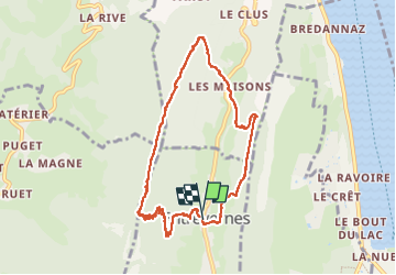
Col de la cochette en boucle depuis Entrevernes

Chabard
User


4h59
Difficulty : Medium

FREE GPS app for hiking
 SityTrail
IGN / Geographical institutes
SityTrail Plus
The world is yours!
About
Trail Walking of 9.1 km to be discovered at Auvergne-Rhône-Alpes, Upper Savoy, Entrevernes. This trail is proposed by Chabard.
Description
Départ du parking de l'église à Entrevernes.
Montée au col de la Cochette. Poursuite jusqu'à la montagne d'Entrevernes avec ascension à la croix.
Chemin de crête puis descente sur Les Maisons.
Remontée sur la crête du Taillefer jusqu'à la descente sur Entrevernes.
Positioning
Comments