


Camp 2024 - Belvedère - La Clusaz

norbertmarteau
User
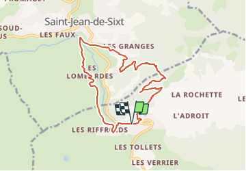

Length
8.1 km

Max alt
1396 m

Uphill gradient
549 m
Km-Effort
15.5 km

Min alt
944 m

Downhill gradient
555 m
Boucle
Yes
Creation date :
2024-08-03 21:13:41.312
Updated on :
2024-08-03 21:22:13.846
3h30
Difficulty : Difficult

FREE GPS app for hiking
 SityTrail
IGN / Geographical institutes
SityTrail Plus
The world is yours!
About
Trail Walking of 8.1 km to be discovered at Auvergne-Rhône-Alpes, Upper Savoy, La Clusaz. This trail is proposed by norbertmarteau.
Positioning
Country:
France
Region :
Auvergne-Rhône-Alpes
Department/Province :
Upper Savoy
Municipality :
La Clusaz
Location:
Unknown
Start:(Dec)
Start:(UTM)
300305 ; 5086829 (32T) N.
Comments