


Piton CRÈVE cœur

Jean-Luc Farant
User GUIDE
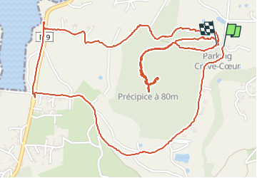

Length
6.2 km

Max alt
181 m

Uphill gradient
235 m
Km-Effort
9.3 km

Min alt
6 m

Downhill gradient
230 m
Boucle
Yes
Creation date :
2024-08-04 12:36:30.0
Updated on :
2024-08-04 16:18:23.079

FREE GPS app for hiking
 SityTrail
IGN / Geographical institutes
SityTrail Plus
The world is yours!
About
Trail of 6.2 km to be discovered at Martinique, Unknown, Sainte-Anne. This trail is proposed by Jean-Luc Farant.
Photos


Positioning
Country:
France
Region :
Martinique
Department/Province :
Unknown
Municipality :
Sainte-Anne
Location:
Unknown
Start:(Dec)
Start:(UTM)
731609 ; 1598820 (20P) N.
Comments