


Col du Perthus la Pezade Cornus Route des Fermes le Clapier Roqueronde

ARVIEU
User
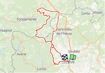

Length
85 km

Max alt
839 m

Uphill gradient
1778 m
Km-Effort
109 km

Min alt
155 m

Downhill gradient
1779 m
Boucle
Yes
Creation date :
2024-08-04 18:04:24.972
Updated on :
2024-08-04 18:06:24.997
4h30
Difficulty : Medium

FREE GPS app for hiking
 SityTrail
IGN / Geographical institutes
SityTrail Plus
The world is yours!
About
Trail Cycle of 85 km to be discovered at Occitania, Hérault, Lodève. This trail is proposed by ARVIEU.
Positioning
Country:
France
Region :
Occitania
Department/Province :
Hérault
Municipality :
Lodève
Location:
Unknown
Start:(Dec)
Start:(UTM)
526049 ; 4841256 (31T) N.
Comments