


drsc du R8

jmheydorff
User
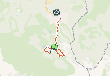

Length
4.1 km

Max alt
2168 m

Uphill gradient
51 m
Km-Effort
5.8 km

Min alt
1876 m

Downhill gradient
330 m
Boucle
No
Creation date :
2024-08-04 08:33:57.565
Updated on :
2024-08-05 08:03:15.258
1h25
Difficulty : Easy

FREE GPS app for hiking
 SityTrail
IGN / Geographical institutes
SityTrail Plus
The world is yours!
About
Trail Walking of 4.1 km to be discovered at Provence-Alpes-Côte d'Azur, Hautes-Alpes, Risoul. This trail is proposed by jmheydorff.
Positioning
Country:
France
Region :
Provence-Alpes-Côte d'Azur
Department/Province :
Hautes-Alpes
Municipality :
Risoul
Location:
Unknown
Start:(Dec)
Start:(UTM)
311906 ; 4942213 (32T) N.
Comments