


Camp réel rando 1

norbertmarteau
User
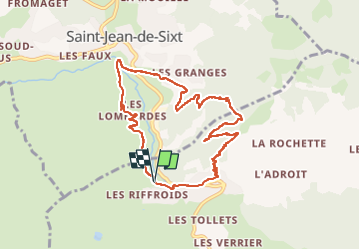

Length
9.6 km

Max alt
1396 m

Uphill gradient
562 m
Km-Effort
17.1 km

Min alt
944 m

Downhill gradient
568 m
Boucle
Yes
Creation date :
2024-08-04 09:04:57.0
Updated on :
2024-08-05 08:54:46.585

FREE GPS app for hiking
 SityTrail
IGN / Geographical institutes
SityTrail Plus
The world is yours!
About
Trail of 9.6 km to be discovered at Auvergne-Rhône-Alpes, Upper Savoy, La Clusaz. This trail is proposed by norbertmarteau.
Positioning
Country:
France
Region :
Auvergne-Rhône-Alpes
Department/Province :
Upper Savoy
Municipality :
La Clusaz
Location:
Unknown
Start:(Dec)
Start:(UTM)
299785 ; 5086897 (32T) N.
Comments