


Murat

bouscaillou
User
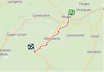

Length
12.8 km

Max alt
1394 m

Uphill gradient
694 m
Km-Effort
20 km

Min alt
885 m

Downhill gradient
205 m
Boucle
No
Creation date :
2024-08-05 09:02:44.016
Updated on :
2024-08-05 14:37:42.783
5h31
Difficulty : Very difficult

FREE GPS app for hiking
 SityTrail
IGN / Geographical institutes
SityTrail Plus
The world is yours!
About
Trail Walking of 12.8 km to be discovered at Auvergne-Rhône-Alpes, Cantal, Murat. This trail is proposed by bouscaillou.
Positioning
Country:
France
Region :
Auvergne-Rhône-Alpes
Department/Province :
Cantal
Municipality :
Murat
Location:
Murat
Start:(Dec)
Start:(UTM)
489835 ; 4995096 (31T) N.
Comments