


Col de l’Egue _ Tarbésou _ lacs de Rabassoles 05/08/2024

Isabelle07
User
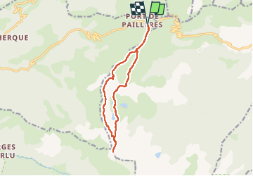

Length
13.1 km

Max alt
2351 m

Uphill gradient
785 m
Km-Effort
24 km

Min alt
1927 m

Downhill gradient
785 m
Boucle
Yes
Creation date :
2024-08-05 07:10:49.302
Updated on :
2024-08-05 14:53:20.037
7h41
Difficulty : Difficult

FREE GPS app for hiking
 SityTrail
IGN / Geographical institutes
SityTrail Plus
The world is yours!
About
Trail Walking of 13.1 km to be discovered at Occitania, Ariège, Ascou. This trail is proposed by Isabelle07.
Positioning
Country:
France
Region :
Occitania
Department/Province :
Ariège
Municipality :
Ascou
Location:
Unknown
Start:(Dec)
Start:(UTM)
417156 ; 4731666 (31T) N.
Comments