


SityTrail - Kirbon

affinetataille
User GUIDE

Length
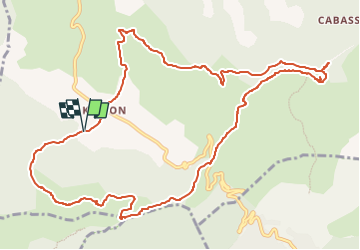
13.6 km

Max alt
702 m

Uphill gradient
531 m
Km-Effort
21 km

Min alt
366 m

Downhill gradient
534 m
Boucle
Yes
Creation date :
2024-08-05 16:20:46.578
Updated on :
2024-12-12 17:23:25.158
6h00
Difficulty : Medium

FREE GPS app for hiking
 SityTrail
IGN / Geographical institutes
SityTrail Plus
The world is yours!
About
Trail Walking of 13.6 km to be discovered at Provence-Alpes-Côte d'Azur, Bouches-du-Rhône, Trets. This trail is proposed by affinetataille.
Positioning
Country:
France
Region :
Provence-Alpes-Côte d'Azur
Department/Province :
Bouches-du-Rhône
Municipality :
Trets
Location:
Unknown
Start:(Dec)
Start:(UTM)
715655 ; 4809903 (31T) N.
Comments