


la balmotte

FERREREMARC
User
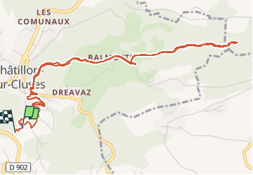

Length
7.1 km

Max alt
895 m

Uphill gradient
280 m
Km-Effort
10.9 km

Min alt
632 m

Downhill gradient
303 m
Boucle
Yes
Creation date :
2024-08-06 06:02:56.318
Updated on :
2024-08-06 07:44:51.962
1h41
Difficulty : Medium

FREE GPS app for hiking
 SityTrail
IGN / Geographical institutes
SityTrail Plus
The world is yours!
About
Trail Walking of 7.1 km to be discovered at Auvergne-Rhône-Alpes, Upper Savoy, Châtillon-sur-Cluses. This trail is proposed by FERREREMARC.
Description
la balmotte
Positioning
Country:
France
Region :
Auvergne-Rhône-Alpes
Department/Province :
Upper Savoy
Municipality :
Châtillon-sur-Cluses
Location:
Unknown
Start:(Dec)
Start:(UTM)
313141 ; 5106043 (32T) N.
Comments