


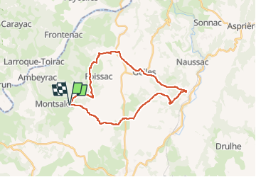
Causse de Gelles depuis Montsalès

Levillefranchois
User

Length
28 km

Max alt
385 m

Uphill gradient
502 m
Km-Effort
34 km

Min alt
233 m

Downhill gradient
502 m
Boucle
Yes
Creation date :
2024-08-06 07:01:43.0
Updated on :
2024-08-06 14:43:50.794
2h10
Difficulty : Easy

FREE GPS app for hiking
 SityTrail
IGN / Geographical institutes
SityTrail Plus
The world is yours!
About
Trail Mountain bike of 28 km to be discovered at Occitania, Aveyron, Montsalès. This trail is proposed by Levillefranchois.
Description
Partir depuis l'aire de camping-car de la Charcuterie du Causse à Montsalès, sur la D87
Pas de difficultés, une montée un peu raide au dessus du Mas de Cambon.
Photos


Positioning
Country:
France
Region :
Occitania
Department/Province :
Aveyron
Municipality :
Montsalès
Location:
Unknown
Start:(Dec)
Start:(UTM)
418611 ; 4926873 (31T) N.
Comments