


Etape 7 - Murat St Gervais

Alain28/01
User
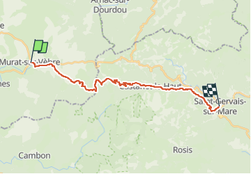

Length
23 km

Max alt
1024 m

Uphill gradient
413 m
Km-Effort
30 km

Min alt
329 m

Downhill gradient
925 m
Boucle
No
Creation date :
2024-08-06 16:06:33.984
Updated on :
2024-08-06 16:07:58.656
6h53
Difficulty : Medium

FREE GPS app for hiking
 SityTrail
IGN / Geographical institutes
SityTrail Plus
The world is yours!
About
Trail Walking of 23 km to be discovered at Occitania, Tarn, Murat-sur-Vèbre. This trail is proposed by Alain28/01.
Positioning
Country:
France
Region :
Occitania
Department/Province :
Tarn
Municipality :
Murat-sur-Vèbre
Location:
Unknown
Start:(Dec)
Start:(UTM)
488342 ; 4836857 (31T) N.
Comments