


baumont

etak
User
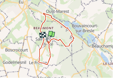

Length
13.8 km

Max alt
138 m

Uphill gradient
270 m
Km-Effort
17.4 km

Min alt
4 m

Downhill gradient
267 m
Boucle
Yes
Creation date :
2024-08-07 08:43:10.891
Updated on :
2024-08-07 12:46:56.875
3h30
Difficulty : Difficult

FREE GPS app for hiking
 SityTrail
IGN / Geographical institutes
SityTrail Plus
The world is yours!
About
Trail Walking of 13.8 km to be discovered at Normandy, Seine-Maritime, Saint-Pierre-en-Val. This trail is proposed by etak.
Positioning
Country:
France
Region :
Normandy
Department/Province :
Seine-Maritime
Municipality :
Saint-Pierre-en-Val
Location:
Unknown
Start:(Dec)
Start:(UTM)
388726 ; 5542148 (31U) N.
Comments