


15/04/2015 Rando ski Pic de Rulhe

chrisbal
User
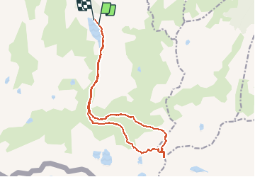

Length
21 km

Max alt
2768 m

Uphill gradient
1296 m
Km-Effort
38 km

Min alt
1529 m

Downhill gradient
1317 m
Boucle
No
Creation date :
2017-05-25 00:00:00.0
Updated on :
2020-06-16 13:02:27.755
--
Difficulty : Difficult

FREE GPS app for hiking
 SityTrail
IGN / Geographical institutes
SityTrail Plus
The world is yours!
About
Trail Touring skiing of 21 km to be discovered at Occitania, Ariège, Aston. This trail is proposed by chrisbal.
Positioning
Country:
France
Region :
Occitania
Department/Province :
Ariège
Municipality :
Aston
Location:
Unknown
Start:(Dec)
Start:(UTM)
394067 ; 4725498 (31T) N.
Comments