


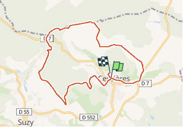
Cessieres du 03/08/2024

VANDERPUTTENMi
User GUIDE

Length
9 km

Max alt
190 m

Uphill gradient
182 m
Km-Effort
11.4 km

Min alt
97 m

Downhill gradient
174 m
Boucle
Yes
Creation date :
2024-08-03 11:48:30.949
Updated on :
2024-08-08 12:25:55.103
2h04
Difficulty : Medium

FREE GPS app for hiking
 SityTrail
IGN / Geographical institutes
SityTrail Plus
The world is yours!
About
Trail Walking of 9 km to be discovered at Hauts-de-France, Aisne, Cessières-Suzy. This trail is proposed by VANDERPUTTENMi.
Positioning
Country:
France
Region :
Hauts-de-France
Department/Province :
Aisne
Municipality :
Cessières-Suzy
Location:
Unknown
Start:(Dec)
Start:(UTM)
535877 ; 5489751 (31U) N.
Comments