


Lac de Gers et retour Samoens

Iahns
User
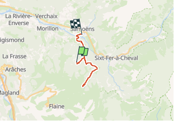

Length
16.7 km

Max alt
1548 m

Uphill gradient
565 m
Km-Effort
26 km

Min alt
698 m

Downhill gradient
986 m
Boucle
No
Creation date :
2024-08-08 08:05:39.757
Updated on :
2024-08-08 14:41:44.1
5h12
Difficulty : Medium

FREE GPS app for hiking
 SityTrail
IGN / Geographical institutes
SityTrail Plus
The world is yours!
About
Trail Walking of 16.7 km to be discovered at Auvergne-Rhône-Alpes, Upper Savoy, Samoëns. This trail is proposed by Iahns.
Positioning
Country:
France
Region :
Auvergne-Rhône-Alpes
Department/Province :
Upper Savoy
Municipality :
Samoëns
Location:
Unknown
Start:(Dec)
Start:(UTM)
323544 ; 5102185 (32T) N.
Comments