


Lac d’Estom

lebarça
User
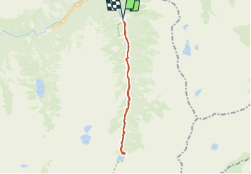

Length
13.1 km

Max alt
1825 m

Uphill gradient
479 m
Km-Effort
19.5 km

Min alt
1364 m

Downhill gradient
480 m
Boucle
Yes
Creation date :
2024-08-08 09:56:41.0
Updated on :
2024-08-08 16:32:20.57

FREE GPS app for hiking
 SityTrail
IGN / Geographical institutes
SityTrail Plus
The world is yours!
About
Trail of 13.1 km to be discovered at Occitania, Hautespyrenees, Cauterets. This trail is proposed by lebarça.
Positioning
Country:
France
Region :
Occitania
Department/Province :
Hautespyrenees
Municipality :
Cauterets
Location:
Unknown
Start:(Dec)
Start:(UTM)
737008 ; 4748923 (30T) N.
Comments