


de mercurey au camp romain

XavierFaidix
User
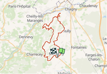

Length
34 km

Max alt
429 m

Uphill gradient
1111 m
Km-Effort
48 km

Min alt
226 m

Downhill gradient
1113 m
Boucle
Yes
Creation date :
2024-08-08 11:56:25.279
Updated on :
2024-08-08 20:27:07.787
3h30
Difficulty : Medium

FREE GPS app for hiking
 SityTrail
IGN / Geographical institutes
SityTrail Plus
The world is yours!
About
Trail Mountain bike of 34 km to be discovered at Bourgogne-Franche-Comté, Saône-et-Loire, Mercurey. This trail is proposed by XavierFaidix.
Positioning
Country:
France
Region :
Bourgogne-Franche-Comté
Department/Province :
Saône-et-Loire
Municipality :
Mercurey
Location:
Bourgneuf-Val-d'Or
Start:(Dec)
Start:(UTM)
631316 ; 5188067 (31T) N.
Comments