


barbacane pintât G4

LouisROGER
User GUIDE
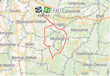

Length
12 km

Max alt
508 m

Uphill gradient
229 m
Km-Effort
15 km

Min alt
379 m

Downhill gradient
230 m
Boucle
Yes
Creation date :
2024-08-09 07:35:25.454
Updated on :
2024-08-09 13:09:41.258
5h33
Difficulty : Difficult

FREE GPS app for hiking
 SityTrail
IGN / Geographical institutes
SityTrail Plus
The world is yours!
About
Trail Walking of 12 km to be discovered at Occitania, Hautespyrenees, Barbazan-Debat. This trail is proposed by LouisROGER.
Positioning
Country:
France
Region :
Occitania
Department/Province :
Hautespyrenees
Municipality :
Barbazan-Debat
Location:
Unknown
Start:(Dec)
Start:(UTM)
266889 ; 4787042 (31T) N.
Comments