


Grandvabre

bouscaillou
User
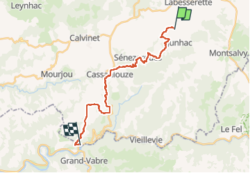

Length
24 km

Max alt
584 m

Uphill gradient
644 m
Km-Effort
34 km

Min alt
215 m

Downhill gradient
954 m
Boucle
No
Creation date :
2024-08-09 06:27:01.72
Updated on :
2024-08-09 16:42:10.837
10h06
Difficulty : Very difficult

FREE GPS app for hiking
 SityTrail
IGN / Geographical institutes
SityTrail Plus
The world is yours!
About
Trail Walking of 24 km to be discovered at Auvergne-Rhône-Alpes, Cantal, Junhac. This trail is proposed by bouscaillou.
Positioning
Country:
France
Region :
Auvergne-Rhône-Alpes
Department/Province :
Cantal
Municipality :
Junhac
Location:
Unknown
Start:(Dec)
Start:(UTM)
456240 ; 4952392 (31T) N.
Comments