


gtj j2

yvesconnes
User
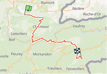

Length
26 km

Max alt
917 m

Uphill gradient
850 m
Km-Effort
37 km

Min alt
383 m

Downhill gradient
714 m
Boucle
No
Creation date :
2024-08-09 06:26:02.478
Updated on :
2024-08-09 16:47:21.268
7h31
Difficulty : Very difficult

FREE GPS app for hiking
 SityTrail
IGN / Geographical institutes
SityTrail Plus
The world is yours!
About
Trail Walking of 26 km to be discovered at Bourgogne-Franche-Comté, Doubs, Montécheroux. This trail is proposed by yvesconnes.
Positioning
Country:
France
Region :
Bourgogne-Franche-Comté
Department/Province :
Doubs
Municipality :
Montécheroux
Location:
Unknown
Start:(Dec)
Start:(UTM)
333727 ; 5248096 (32T) N.
Comments