


col de la loge

josy31
User

Length
10.5 km

Max alt
1254 m

Uphill gradient
324 m
Km-Effort
14.9 km

Min alt
1003 m

Downhill gradient
325 m
Boucle
Yes
Creation date :
2024-08-07 07:35:15.69
Updated on :
2024-08-10 09:11:51.969
2h59
Difficulty : Medium

FREE GPS app for hiking
 SityTrail
IGN / Geographical institutes
SityTrail Plus
The world is yours!
About
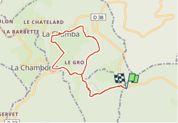
Trail Walking of 10.5 km to be discovered at Auvergne-Rhône-Alpes, Loire, Chalmazel-Jeansagnière. This trail is proposed by josy31.
Description
Belle randonnée autour du col. Très beaux points de vue.
Positioning
Country:
France
Region :
Auvergne-Rhône-Alpes
Department/Province :
Loire
Municipality :
Chalmazel-Jeansagnière
Location:
Jeansagnière
Start:(Dec)
Start:(UTM)
560741 ; 5065696 (31T) N.
Comments