


Le Puy en Velay

MAUVAGE Patrick
User
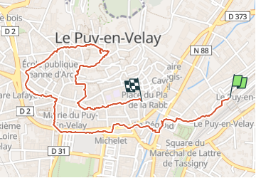

Length
2.8 km

Max alt
696 m

Uphill gradient
72 m
Km-Effort
3.8 km

Min alt
622 m

Downhill gradient
70 m
Boucle
No
Creation date :
2024-08-10 08:40:37.0
Updated on :
2024-08-19 04:45:57.118
51m
Difficulty : Easy

FREE GPS app for hiking
 SityTrail
IGN / Geographical institutes
SityTrail Plus
The world is yours!
About
Trail Walking of 2.8 km to be discovered at Auvergne-Rhône-Alpes, Haute-Loire, Le Puy-en-Velay. This trail is proposed by MAUVAGE Patrick.
Positioning
Country:
France
Region :
Auvergne-Rhône-Alpes
Department/Province :
Haute-Loire
Municipality :
Le Puy-en-Velay
Location:
Unknown
Start:(Dec)
Start:(UTM)
570325 ; 4988158 (31T) N.
Comments