


cheval blanc

herveschmitt
User
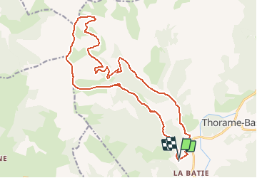

Length
23 km

Max alt
2304 m

Uphill gradient
1329 m
Km-Effort
41 km

Min alt
1098 m

Downhill gradient
1332 m
Boucle
Yes
Creation date :
2019-05-02 07:31:43.94
Updated on :
2020-05-26 17:30:59.728
5h00
Difficulty : Unknown

FREE GPS app for hiking
 SityTrail
IGN / Geographical institutes
SityTrail Plus
The world is yours!
About
Trail Other activity of 23 km to be discovered at Provence-Alpes-Côte d'Azur, Alpes-de-Haute-Provence, Thorame-Basse. This trail is proposed by herveschmitt.
Positioning
Country:
France
Region :
Provence-Alpes-Côte d'Azur
Department/Province :
Alpes-de-Haute-Provence
Municipality :
Thorame-Basse
Location:
Unknown
Start:(Dec)
Start:(UTM)
297606 ; 4883646 (32T) N.
Comments