


Wikiloc - Seix wandelroute Geel

pidjam
User
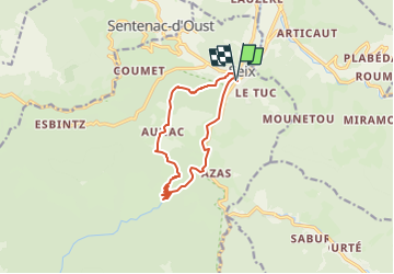

Length
11.4 km

Max alt
895 m

Uphill gradient
527 m
Km-Effort
18.5 km

Min alt
511 m

Downhill gradient
526 m
Boucle
Yes
Creation date :
2024-08-11 07:47:31.127
Updated on :
2024-08-11 07:57:35.013
4h11
Difficulty : Difficult

FREE GPS app for hiking
 SityTrail
IGN / Geographical institutes
SityTrail Plus
The world is yours!
About
Trail Walking of 11.4 km to be discovered at Occitania, Ariège, Seix. This trail is proposed by pidjam.
Positioning
Country:
France
Region :
Occitania
Department/Province :
Ariège
Municipality :
Seix
Location:
Unknown
Start:(Dec)
Start:(UTM)
353096 ; 4747233 (31T) N.
Comments