


montagnette

nordan
User
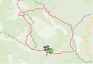

Length
10.5 km

Max alt
1959 m

Uphill gradient
720 m
Km-Effort
20 km

Min alt
1365 m

Downhill gradient
712 m
Boucle
No
Creation date :
2024-08-11 07:38:07.753
Updated on :
2024-08-11 16:08:29.027
3h44
Difficulty : Medium

FREE GPS app for hiking
 SityTrail
IGN / Geographical institutes
SityTrail Plus
The world is yours!
About
Trail Walking of 10.5 km to be discovered at Auvergne-Rhône-Alpes, Drôme, Châtillon-en-Diois. This trail is proposed by nordan.
Positioning
Country:
France
Region :
Auvergne-Rhône-Alpes
Department/Province :
Drôme
Municipality :
Châtillon-en-Diois
Location:
Treschenu-Creyers
Start:(Dec)
Start:(UTM)
702923 ; 4959989 (31T) N.
Comments