


grj j5

yvesconnes
User
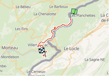

Length
17.2 km

Max alt
1160 m

Uphill gradient
780 m
Km-Effort
26 km

Min alt
722 m

Downhill gradient
403 m
Boucle
No
Creation date :
2024-08-12 06:24:59.585
Updated on :
2024-08-12 13:56:35.682
4h49
Difficulty : Very difficult

FREE GPS app for hiking
 SityTrail
IGN / Geographical institutes
SityTrail Plus
The world is yours!
About
Trail Walking of 17.2 km to be discovered at Bourgogne-Franche-Comté, Doubs, Villers-le-Lac. This trail is proposed by yvesconnes.
Positioning
Country:
France
Region :
Bourgogne-Franche-Comté
Department/Province :
Doubs
Municipality :
Villers-le-Lac
Location:
Unknown
Start:(Dec)
Start:(UTM)
328668 ; 5218964 (32T) N.
Comments