


Chetel St Germain 9,3 km HS

bstebe
User
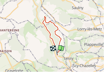

Length
9.3 km

Max alt
360 m

Uphill gradient
208 m
Km-Effort
12.1 km

Min alt
204 m

Downhill gradient
209 m
Boucle
Yes
Creation date :
2024-08-13 07:26:26.35
Updated on :
2024-08-13 10:18:15.491
2h51
Difficulty : Difficult

FREE GPS app for hiking
 SityTrail
IGN / Geographical institutes
SityTrail Plus
The world is yours!
About
Trail Walking of 9.3 km to be discovered at Grand Est, Moselle, Châtel-Saint-Germain. This trail is proposed by bstebe.
Positioning
Country:
France
Region :
Grand Est
Department/Province :
Moselle
Municipality :
Châtel-Saint-Germain
Location:
Unknown
Start:(Dec)
Start:(UTM)
287086 ; 5445227 (32U) N.
Comments