


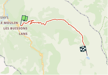
Lac des sagnes

andre06130
User

Length
10.3 km

Max alt
1908 m

Uphill gradient
577 m
Km-Effort
16.1 km

Min alt
1365 m

Downhill gradient
38 m
Boucle
No
Creation date :
2024-08-13 10:31:35.52
Updated on :
2024-08-17 14:51:24.969
3h40
Difficulty : Difficult
0m
Difficulty : Very easy

FREE GPS app for hiking
 SityTrail
IGN / Geographical institutes
SityTrail Plus
The world is yours!
About
Trail Walking of 10.3 km to be discovered at Provence-Alpes-Côte d'Azur, Alpes-de-Haute-Provence, Jausiers. This trail is proposed by andre06130.
Positioning
Country:
France
Region :
Provence-Alpes-Côte d'Azur
Department/Province :
Alpes-de-Haute-Provence
Municipality :
Jausiers
Location:
Unknown
Start:(Dec)
Start:(UTM)
321337 ; 4920168 (32T) N.
Comments