


Saint-Andéol-de_Vals

Rudy07
User
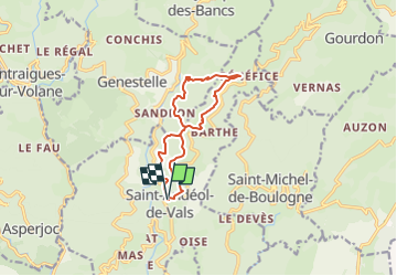

Length
11.1 km

Max alt
689 m

Uphill gradient
365 m
Km-Effort
16 km

Min alt
481 m

Downhill gradient
366 m
Boucle
Yes
Creation date :
2024-08-13 15:14:24.379
Updated on :
2024-11-04 09:06:29.114
3h38
Difficulty : Medium

FREE GPS app for hiking
 SityTrail
IGN / Geographical institutes
SityTrail Plus
The world is yours!
About
Trail Walking of 11.1 km to be discovered at Auvergne-Rhône-Alpes, Ardèche, Saint-Andéol-de-Vals. This trail is proposed by Rudy07.
Positioning
Country:
France
Region :
Auvergne-Rhône-Alpes
Department/Province :
Ardèche
Municipality :
Saint-Andéol-de-Vals
Location:
Unknown
Start:(Dec)
Start:(UTM)
611049 ; 4949785 (31T) N.
Comments