


gjt j6 suite

yvesconnes
User
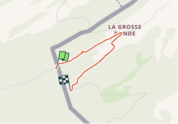

Length
2.2 km

Max alt
1175 m

Uphill gradient
148 m
Km-Effort
3.7 km

Min alt
1024 m

Downhill gradient
2 m
Boucle
No
Creation date :
2024-08-13 15:19:35.943
Updated on :
2024-08-13 16:54:49.545
30m
Difficulty : Very difficult

FREE GPS app for hiking
 SityTrail
IGN / Geographical institutes
SityTrail Plus
The world is yours!
About
Trail Walking of 2.2 km to be discovered at Bourgogne-Franche-Comté, Doubs, Pontarlier. This trail is proposed by yvesconnes.
Positioning
Country:
France
Region :
Bourgogne-Franche-Comté
Department/Province :
Doubs
Municipality :
Pontarlier
Location:
Unknown
Start:(Dec)
Start:(UTM)
304620 ; 5200195 (32T) N.
Comments