


Prem cap 20240814

Valery01
User
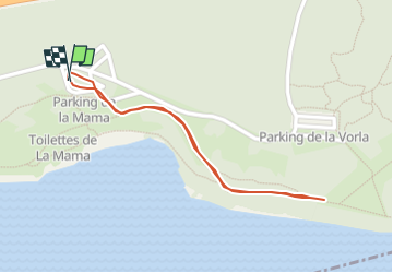

Length
966 m

Max alt
182 m

Uphill gradient
6 m
Km-Effort
1 km

Min alt
175 m

Downhill gradient
7 m
Boucle
Yes
Creation date :
2024-08-14 09:21:08.0
Updated on :
2024-08-14 09:29:25.414
7m
Difficulty : Unknown

FREE GPS app for hiking
 SityTrail
IGN / Geographical institutes
SityTrail Plus
The world is yours!
About
Trail Running of 966 m to be discovered at Auvergne-Rhône-Alpes, Ain, Miribel. This trail is proposed by Valery01.
Positioning
Country:
France
Region :
Auvergne-Rhône-Alpes
Department/Province :
Ain
Municipality :
Miribel
Location:
Unknown
Start:(Dec)
Start:(UTM)
651997 ; 5075185 (31T) N.
Comments