


De Val Ubaye vers Salette en coupant

damlou
User
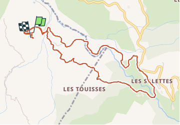

Length
6.2 km

Max alt
1146 m

Uphill gradient
231 m
Km-Effort
9.2 km

Min alt
948 m

Downhill gradient
219 m
Boucle
Yes
Creation date :
2024-08-14 15:39:38.604
Updated on :
2024-08-14 17:57:20.836
1h37
Difficulty : Medium

FREE GPS app for hiking
 SityTrail
IGN / Geographical institutes
SityTrail Plus
The world is yours!
About
Trail Walking of 6.2 km to be discovered at Provence-Alpes-Côte d'Azur, Hautes-Alpes, Baratier. This trail is proposed by damlou.
Description
Balade jolie et variée
Positioning
Country:
France
Region :
Provence-Alpes-Côte d'Azur
Department/Province :
Hautes-Alpes
Municipality :
Baratier
Location:
Unknown
Start:(Dec)
Start:(UTM)
301444 ; 4933413 (32T) N.
Comments