


lac de lignin

Pascal84
User
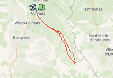

Length
30 km

Max alt
2291 m

Uphill gradient
1210 m
Km-Effort
46 km

Min alt
1236 m

Downhill gradient
1206 m
Boucle
Yes
Creation date :
2024-08-13 06:41:00.291
Updated on :
2024-08-14 18:09:31.521
8h29
Difficulty : Difficult

FREE GPS app for hiking
 SityTrail
IGN / Geographical institutes
SityTrail Plus
The world is yours!
About
Trail Walking of 30 km to be discovered at Provence-Alpes-Côte d'Azur, Alpes-de-Haute-Provence, Colmars. This trail is proposed by Pascal84.
Positioning
Country:
France
Region :
Provence-Alpes-Côte d'Azur
Department/Province :
Alpes-de-Haute-Provence
Municipality :
Colmars
Location:
Unknown
Start:(Dec)
Start:(UTM)
310208 ; 4894499 (32T) N.
Comments