


vers l'Izoard cascades des Oules Cervières

bernir
User
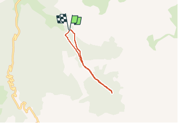

Length
4.7 km

Max alt
2151 m

Uphill gradient
279 m
Km-Effort
8.4 km

Min alt
1867 m

Downhill gradient
275 m
Boucle
Yes
Creation date :
2024-08-14 12:37:21.074
Updated on :
2024-09-17 12:25:29.305
1h54
Difficulty : Medium

FREE GPS app for hiking
 SityTrail
IGN / Geographical institutes
SityTrail Plus
The world is yours!
About
Trail Walking of 4.7 km to be discovered at Provence-Alpes-Côte d'Azur, Hautes-Alpes, Cervières. This trail is proposed by bernir.
Positioning
Country:
France
Region :
Provence-Alpes-Côte d'Azur
Department/Province :
Hautes-Alpes
Municipality :
Cervières
Location:
Unknown
Start:(Dec)
Start:(UTM)
321654 ; 4968357 (32T) N.
Comments