


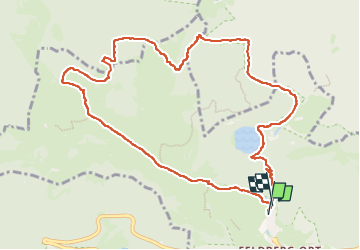
sommet du feldberg et retour par feldsee

OxygenLT
User

Length
11.2 km

Max alt
1492 m

Uphill gradient
533 m
Km-Effort
18.2 km

Min alt
1117 m

Downhill gradient
528 m
Boucle
Yes
Creation date :
2024-08-15 08:03:45.795
Updated on :
2024-08-15 11:45:25.347
3h41
Difficulty : Difficult

FREE GPS app for hiking
 SityTrail
IGN / Geographical institutes
SityTrail Plus
The world is yours!
About
Trail Walking of 11.2 km to be discovered at Baden-Württemberg, Landkreis Breisgau-Hochschwarzwald, Feldberg. This trail is proposed by OxygenLT.
Positioning
Country:
Germany
Region :
Baden-Württemberg
Department/Province :
Landkreis Breisgau-Hochschwarzwald
Municipality :
Feldberg
Location:
Feldberg (Ort)
Start:(Dec)
Start:(UTM)
427896 ; 5301399 (32T) N.
Comments