


gtj j 8

yvesconnes
User

Length
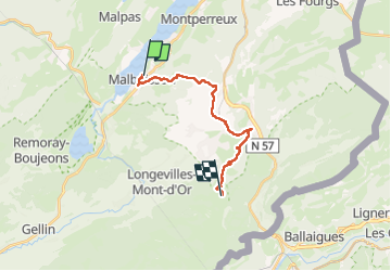
15.7 km

Max alt
1417 m

Uphill gradient
721 m
Km-Effort
24 km

Min alt
880 m

Downhill gradient
253 m
Boucle
No
Creation date :
2024-08-15 09:11:21.599
Updated on :
2024-08-15 21:43:32.678
4h40
Difficulty : Very difficult

FREE GPS app for hiking
 SityTrail
IGN / Geographical institutes
SityTrail Plus
The world is yours!
About
Trail Walking of 15.7 km to be discovered at Bourgogne-Franche-Comté, Doubs, Malbuisson. This trail is proposed by yvesconnes.
Positioning
Country:
France
Region :
Bourgogne-Franche-Comté
Department/Province :
Doubs
Municipality :
Malbuisson
Location:
Unknown
Start:(Dec)
Start:(UTM)
294429 ; 5186545 (32T) N.
Comments