


Etang d'Ayes

Evelyne Bouchereau
User
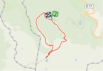

Length
7.2 km

Max alt
1736 m

Uphill gradient
430 m
Km-Effort
12.9 km

Min alt
1404 m

Downhill gradient
418 m
Boucle
Yes
Creation date :
2024-08-13 09:12:31.633
Updated on :
2024-08-16 12:25:16.412
2h05
Difficulty : Difficult

FREE GPS app for hiking
 SityTrail
IGN / Geographical institutes
SityTrail Plus
The world is yours!
About
Trail Walking of 7.2 km to be discovered at Occitania, Ariège, Bethmale. This trail is proposed by Evelyne Bouchereau.
Positioning
Country:
France
Region :
Occitania
Department/Province :
Ariège
Municipality :
Bethmale
Location:
Unknown
Start:(Dec)
Start:(UTM)
342068 ; 4747285 (31T) N.
Comments