


Rando Le Monné

Fab-Oz
User
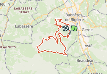

Length
22 km

Max alt
1235 m

Uphill gradient
963 m
Km-Effort
35 km

Min alt
562 m

Downhill gradient
962 m
Boucle
Yes
Creation date :
2024-08-16 07:35:05.373
Updated on :
2024-08-16 13:58:53.822
5h16
Difficulty : Medium

FREE GPS app for hiking
 SityTrail
IGN / Geographical institutes
SityTrail Plus
The world is yours!
About
Trail Walking of 22 km to be discovered at Occitania, Hautespyrenees, Bagnères-de-Bigorre. This trail is proposed by Fab-Oz.
Photos


Positioning
Country:
France
Region :
Occitania
Department/Province :
Hautespyrenees
Municipality :
Bagnères-de-Bigorre
Location:
Unknown
Start:(Dec)
Start:(UTM)
267715 ; 4770394 (31T) N.
Comments