


Seix Cos Aunac Betmajou

pidjam
User
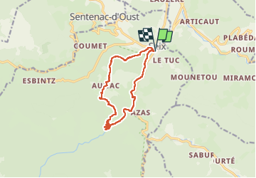

Length
12.7 km

Max alt
897 m

Uphill gradient
547 m
Km-Effort
20 km

Min alt
510 m

Downhill gradient
547 m
Boucle
Yes
Creation date :
2024-08-15 07:24:06.159
Updated on :
2024-08-16 16:46:42.369
3h26
Difficulty : Medium

FREE GPS app for hiking
 SityTrail
IGN / Geographical institutes
SityTrail Plus
The world is yours!
About
Trail Walking of 12.7 km to be discovered at Occitania, Ariège, Seix. This trail is proposed by pidjam.
Positioning
Country:
France
Region :
Occitania
Department/Province :
Ariège
Municipality :
Seix
Location:
Unknown
Start:(Dec)
Start:(UTM)
353148 ; 4747247 (31T) N.
Comments